
Bashi Creek Early morning

Across from Bashi Creek good anchorage

Proud Lady
Whites Bluff at mile 134.5 on the southern shore is over 400 feet high. It takes its name from the area's white limestone. We are in one of the most scenic parts of the lower river; no sign of habitation. The river threads its way along high forested hills and steep cliffs. We have deep water from bank to bank.

White Bluff

White Bluff Area
Your history lesson granddaughters....In 1540 Hernando de Soto noted that the Choctaw Indians kept flocks of turkeys numbering in the thousands. Well he may have been describing a large Choctaw village which sat on both sides of the river near mile 120.4. It was called FaKit Chipuna or "Little Turkeys". The Americans later called the settlement "Tombigbee Turkey Town." The wild turkey is common throughout this region although they blend into the environment so well that they are seldom seen. True fact...but we didn't see any.

River getting WIDE
Bobby's Fish Camp at Mile 118.9. You can tie alongside the 100-foot face dock on first-come basis. There is no electric service. Transient rate $1/ft. They do have a restaurant open Thursday thru Saturday and fuel.
Rik and Don stopped here in 2010 when they were bringing the Nanseann back to Green Turtle Bay. After they pumped their own fuel (had to walk up the hill to turn on the pump), had a beer, ate some catfish, bought a T-shirt...they asked to buy some ice. they were told NO...they were running short. Well Capt. Rik headed his boat upriver. $800 less in his pocket and anchored out that evening. He does not stop at Bobby's Fish Camp!!! That's the story!!! This is the LAST fuel stop until Mobile...wish us luck

You raft to the dock

Walk up the hill to restaurant
They are doing some repairs at Coffeeville Lock and Dam.....slow down and wait. This is a 34 foot drop and our last lock on the waterway. Took us an hour. The work barge took a break, moved out of the lock and let the "pleasure boats" lock thru.

Approaching Coffeeville Lock and Dam

US Corp of Engineers Working
As you leave the lock, we are less than four feet above sea level. We will experience some tidal effect from here to the Gulf.

Gate Opening
Mile 107.1 there is a very sharp turn for towboats. The Army Corps of Engineers has considered building a cutoff in order to straighten the difficult right-angle bend. If a towboat is in the vicinity we may have to stand by and not meet at the turn since rounding the bend often requires backing and shifting to get the tow clear of the point. This is called "Hatchetibee" which means "neck of bottle stream".

Towboat going upbound
We have reached the approximate halfway point between Mobile and the Black Warrior junction.

Another Turn

Wake me when it's time to eat

Lone Star Remains
Lovers Leap....Deeply cracked and colored rock, trees with gnarled roots clinging to the cliff and wisps of Spanish Moss.

Lovers Leap
Call from Julie...couldn't believe we had service...thank you

Railroad Lift Bridge
Bank full of logs...trucks either loading/unloading them. Large pulp and paper mill. Fast growing loblolly pines are the primary wood used.

Those are trees
The bridge is US 43 (Jackson AL). There's not another bridge for 71 miles and the landscape will be even more isolated.

Last Bridge for 71 miles
Come to the Charles R Lowman Power Plant. Barges deliver coal to this plant....very impressive from the water. We didn't see a barge unloading coal.

Big piles of coal
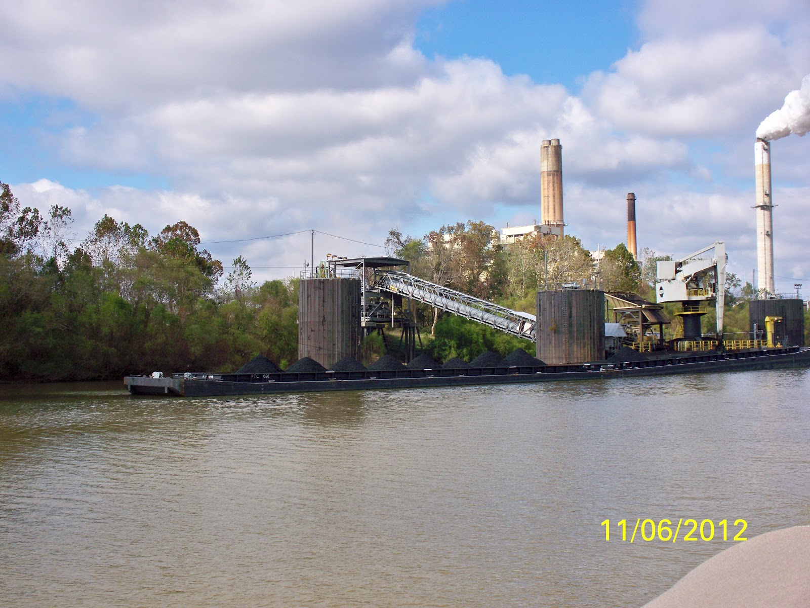
Power Plant

Lady's Landing no more
We tried to anchor at Bates Lake Mile 54.0 but too shallow....tidal waters were out....went on to the Alabama River Cut Off on port (Paul's Bayou on starboard) Mile 52.8 (no day marker and the sun was setting and the depth control was coming and going....made it alittle tense plus the tidal waters were skinny. Bow/Stern anchor holds...appears we have 10 plus feet of water....dark
Served the boys Chicken Enchiladas and we watched the elections for a very short time. 93 miles today.
Sunset

Alabama River Cut Off

Alabama River Cut Off
No comments:
Post a Comment